
Neulassing topographic map
Click on the map to display elevation.
About this map
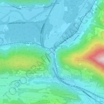
Name: Neulassing topographic map, elevation, terrain.
Location: Neulassing, Selzthal, Bezirk Liezen, Styria, 8900, Austria (47.52594 14.28554 47.56594 14.32554)
Average elevation: 2,454 ft
Minimum elevation: 2,034 ft
Maximum elevation: 4,462 ft
Other topographic maps
Click on a map to view its topography, its elevation and its terrain.
Ramsau am Dachstein
Austria > Styria > Bezirk Liezen
Ramsau am Dachstein is situated between the Dachstein range of mountains in the north and the Enns valley in the south. While the Dachstein range contains peaks up to 2,995 m (9,826 ft) and the towns of the Enns valley, such as Schladming, lie at around 700 m (2,300 ft) above sea level, the Ramsau plateau is a…
Average elevation: 5,007 ft
Grundlsee
Austria > Styria > Bezirk Liezen
The climate in Grundlsee is determined by its geographical location in the Aussee Basin. It is characterized mainly by the high altitude and the location in the northern congestion area. The result is, in the case of flow conditions from the west to the north, often days of precipitation, which in winter are…
Average elevation: 4,068 ft
Ramsau am Dachstein
Austria > Styria > Bezirk Liezen
Ramsau am Dachstein is situated between the Dachstein range of mountains in the north and the Enns valley in the south. While the Dachstein range contains peaks up to 2,995 m (9,826 ft) and the towns of the Enns valley, such as Schladming, lie at around 700 m (2,300 ft) above sea level, the Ramsau plateau is a…
Average elevation: 5,007 ft