Geolocate

Asotin topographic map

Click on the map to display elevation.

Asotin

Asotin is located south of Clarkston, on the west bank of the Snake River. The elevation is 801 feet (244 m) above sea level.

Wikipedia (CC-BY-SA 3.0)

About this map

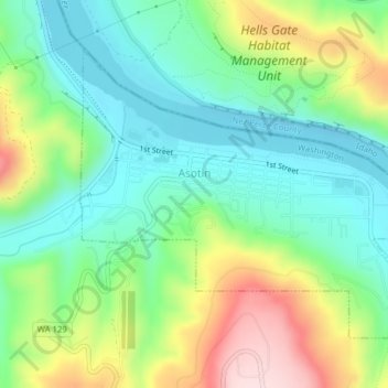
Name: Asotin topographic map, elevation, terrain.

Location: Asotin, Asotin County, Washington, 99402, United States (46.32783 -117.05974 46.34787 -117.02315)

Average elevation: 1,047 ft

Minimum elevation: 712 ft

Maximum elevation: 1,703 ft

Asotin County trails, hiking, mountain biking, running and outdoor activities

Other topographic maps

Click on a map to view its topography, its elevation and its terrain.

Anatone

United States > Washington > Asotin County

Average elevation: 3,599 ft

Gear up for your next adventure:

🧭Pro Hiking Compasses - High-accuracy liquid-filled compasses for topographic orientation
🪶Compact Camp Shovel - Folding shovel for campsite tasks
😴Insulated Sleeping Pads - Compact and warm pads for high-elevation camping
🧣Hiking Neck Gaiter - Multi‑use neck protection for outdoor weather
🔋Solar Power Banks - Keep your GPS and phone charged in remote wilderness areas

As an Amazon Associate, this site earns from qualifying purchases at no extra cost to you.