
Mount Cain topographic map
Interactive map
Click on the map to display elevation.
About this map
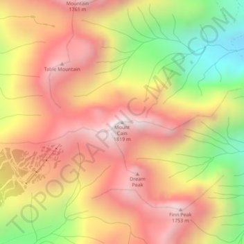
Name: Mount Cain topographic map, elevation, terrain.
Average elevation: 4,360 ft
Minimum elevation: 2,313 ft
Maximum elevation: 5,860 ft
Other topographic maps
Click on a map to view its topography, its elevation and its terrain.
Woss
Canada > British Columbia > Regional District of Mount Waddington > Area D (Nimpkish Valley/Cormorant Island)
Woss, Area D (Nimpkish Valley/Cormorant Island), Regional District of Mount Waddington, British Columbia, V0N 3P0, Canada
Average elevation: 656 ft