
Make a donation
Gear up for your next adventure:
As an Amazon Associate, this site earns from qualifying purchases at no extra cost to you.
Bordighera topographic map
Click on the map to display elevation.
Make a donation
Gear up for your next adventure:
As an Amazon Associate, this site earns from qualifying purchases at no extra cost to you.
Bordighera
It is estimated that the previous day had been cloudy with rain, a shower followed by a thunderstorm the night, with long lightning bolts to the east and west, and an elevation of no less than 2500 feet.
Make a donation
Gear up for your next adventure:
As an Amazon Associate, this site earns from qualifying purchases at no extra cost to you.
About this map
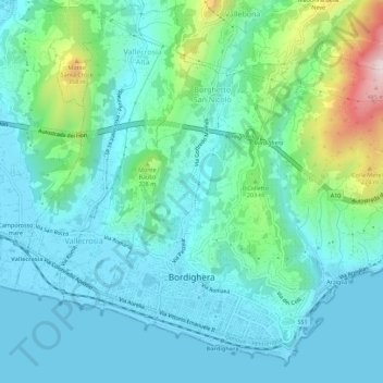
Name: Bordighera topographic map, elevation, terrain.
Location: Bordighera, Imperia, Liguria, 18012, Italy (43.77569 7.64626 43.81229 7.70198)
Average elevation: 335 ft
Minimum elevation: -3 ft
Maximum elevation: 1,670 ft
Make a donation
Gear up for your next adventure:
As an Amazon Associate, this site earns from qualifying purchases at no extra cost to you.
Other topographic maps
Click on a map to view its topography, its elevation and its terrain.
I Palanchi
Italy > Liguria > Imperia > Ventimiglia > Torri Inferiore > Torri Superiore
Average elevation: 1,001 ft