
St Albans topographic map
Click on the map to display elevation.
About this map
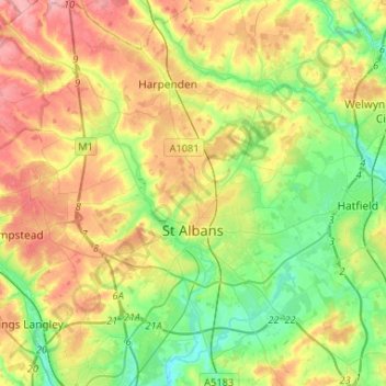
Name: St Albans topographic map, elevation, terrain.
Location: St Albans, Hertfordshire, England, United Kingdom (51.68759 -0.44061 51.84960 -0.24160)
Average elevation: 351 ft
Minimum elevation: 190 ft
Maximum elevation: 571 ft
Other topographic maps
Click on a map to view its topography, its elevation and its terrain.
Welwyn Garden City
United Kingdom > England > Hertfordshire > Welwyn Hatfield
Average elevation: 292 ft
Bishops Stortford Elsan Point
United Kingdom > England > Hertfordshire > East Hertfordshire
Average elevation: 256 ft
Bushey Heath
United Kingdom > England > Hertfordshire > Hertsmere > Bushey Heath
Average elevation: 361 ft