
Mount Russel topographic map
Click on the map to display elevation.
About this map
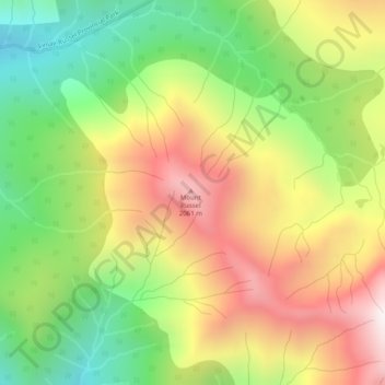
Name: Mount Russel topographic map, elevation, terrain.
Average elevation: 5,417 ft
Minimum elevation: 3,990 ft
Maximum elevation: 7,051 ft
Other topographic maps
Click on a map to view its topography, its elevation and its terrain.
Jack Lake
Canada > British Columbia > Peace River Regional District > Area B (Finlay Valley/Beatton Valley)
Average elevation: 3,268 ft
Obo Lake
Canada > British Columbia > Peace River Regional District > Area B (Finlay Valley/Beatton Valley)
Average elevation: 4,265 ft
Charlie Lake
Canada > British Columbia > Peace River Regional District > Area B (Finlay Valley/Beatton Valley)
Average elevation: 2,497 ft
Inga Lake
Canada > British Columbia > Peace River Regional District > Area B (Finlay Valley/Beatton Valley)
Average elevation: 2,838 ft
Buckinghorse River
Canada > British Columbia > Peace River Regional District > Area B (Finlay Valley/Beatton Valley)
Average elevation: 3,100 ft
Milligan Hills Provincial Park
Canada > British Columbia > Peace River Regional District > Area B (Finlay Valley/Beatton Valley)
Average elevation: 2,871 ft
Buckinghorse River
Canada > British Columbia > Peace River Regional District > Area B (Finlay Valley/Beatton Valley)
Average elevation: 3,937 ft