
Make a donation
Gear up for your next adventure:
As an Amazon Associate, this site earns from qualifying purchases at no extra cost to you.
Limsdorf topographic map
Click on the map to display elevation.
Make a donation
Gear up for your next adventure:
As an Amazon Associate, this site earns from qualifying purchases at no extra cost to you.
About this map
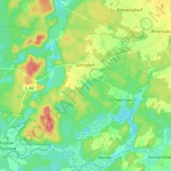
Name: Limsdorf topographic map, elevation, terrain.
Location: Limsdorf, Storkow (Mark), Oder-Spree, Brandenburg, Deutschland (52.11579 13.93335 52.18317 14.06657)
Average elevation: 190 ft
Minimum elevation: 115 ft
Maximum elevation: 328 ft
Make a donation
Gear up for your next adventure:
As an Amazon Associate, this site earns from qualifying purchases at no extra cost to you.
Other topographic maps
Click on a map to view its topography, its elevation and its terrain.
Großer Treppelsee
Deutschland > Brandenburg > Oder-Spree > Schlaubetal > Bremsdorf
Average elevation: 259 ft
Make a donation
Gear up for your next adventure:
As an Amazon Associate, this site earns from qualifying purchases at no extra cost to you.
Make a donation
Gear up for your next adventure:
As an Amazon Associate, this site earns from qualifying purchases at no extra cost to you.
Make a donation
Gear up for your next adventure:
As an Amazon Associate, this site earns from qualifying purchases at no extra cost to you.
Make a donation
Gear up for your next adventure:
As an Amazon Associate, this site earns from qualifying purchases at no extra cost to you.
Make a donation
Gear up for your next adventure:
As an Amazon Associate, this site earns from qualifying purchases at no extra cost to you.
Großer Storkower See
Deutschland > Brandenburg > Oder-Spree > Storkow (Mark)
Das 3,7 km² große Gewässer befindet sich innerhalb der Stadtgrenzen von Storkow (Mark). Es besteht aus dem nördlichen, kleineren und einem langgestreckten, südlichen Becken, die durch eine etwa 200 Meter breite Seeenge miteinander verbunden sind. Der Ort Storkow erstreckt sich am Nord- und Westufer, der…
Average elevation: 151 ft
Klingemühle
Deutschland > Brandenburg > Oder-Spree > Friedland > Chossewitz
Johann Gottfried Kapke heiratete die Witwe und wurde so zum neuen Klingemüller. Noch vor dem Ende des 18. Jahrhunderts folgte ein Besitzer namens Schmettow, der die Klingemühle 1803 an Christian Richter verkaufte. Richter hatte nun die Aufgabe, die heruntergekommene Mühle wieder instand zu setzen. Er erlitt…
Average elevation: 292 ft
Make a donation
Gear up for your next adventure:
As an Amazon Associate, this site earns from qualifying purchases at no extra cost to you.