Geolocate

Shuniah topographic map

Click on the map to display elevation.

About this map

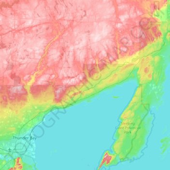
Name: Shuniah topographic map, elevation, terrain.

Location: Shuniah, Thunder Bay District, Northwestern Ontario, Ontario, Canada (48.38486 -89.18855 48.73810 -88.42961)

Average elevation: 1,070 ft

Minimum elevation: 577 ft

Maximum elevation: 1,814 ft

Other topographic maps

Click on a map to view its topography, its elevation and its terrain.

Spooner Lake

Canada > Ontario > Thunder Bay District > Greenstone

Average elevation: 1,152 ft

Nakina

Canada > Ontario > Thunder Bay District > Greenstone > Nakina

Average elevation: 1,050 ft

Schreiber

Canada > Ontario > Thunder Bay District > Schreiber Township

Average elevation: 1,063 ft

Gear up for your next adventure:

📷Action Cameras - Rugged cameras to document your journeys across rugged terrain
🌡️Portable Weather Meter - Track weather conditions on the trail
🎒Waterproof Dry Bags - Keep your electronics and maps dry inside your pack
🧷Carabiner Set - Durable clips for gear attachment
🩹Survival Bandages - High‑quality bandages for emergencies

As an Amazon Associate, this site earns from qualifying purchases at no extra cost to you.