
Make a donation
Gear up for your next adventure:
As an Amazon Associate, this site earns from qualifying purchases at no extra cost to you.
Santa Praxedes topographic map
Click on the map to display elevation.
Make a donation
Gear up for your next adventure:
As an Amazon Associate, this site earns from qualifying purchases at no extra cost to you.
About this map
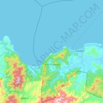
Name: Santa Praxedes topographic map, elevation, terrain.
Location: Santa Praxedes, Cagayan, Cagayan Valley, 3521, Philippines (18.44583 120.93181 18.75818 121.04991)
Average elevation: 515 ft
Minimum elevation: -3 ft
Maximum elevation: 4,167 ft
Make a donation
Gear up for your next adventure:
As an Amazon Associate, this site earns from qualifying purchases at no extra cost to you.
Other topographic maps
Click on a map to view its topography, its elevation and its terrain.
Make a donation
Gear up for your next adventure:
As an Amazon Associate, this site earns from qualifying purchases at no extra cost to you.
Dalupiri Island
Philippines > Cagayan > Calayan
Dalupiri Island lies about 45 km (28 mi) north of Luzon and about 15 km (9.3 mi) north of Fuga Island. The island has an elongated elliptical shape orientated along a north–south axis, the island has a length of about 18 km (11 mi), with a width of about 7 km (4.3 mi) at its widest point. The topography of…
Average elevation: 82 ft
Make a donation
Gear up for your next adventure:
As an Amazon Associate, this site earns from qualifying purchases at no extra cost to you.
Make a donation
Gear up for your next adventure:
As an Amazon Associate, this site earns from qualifying purchases at no extra cost to you.
Rizal
The Sinicking National Park has the height of 801 metres (2,628 ft) and the highest elevation between the town's Poblacion and barangay Gaddangao is 1,004 metres (3,294 ft). The entrance to the town is very similar to the Kennon Road of Baguio.
Average elevation: 505 ft
Make a donation
Gear up for your next adventure:
As an Amazon Associate, this site earns from qualifying purchases at no extra cost to you.
Enrile
Philippines > Cagayan > Enrile
Enrile is bounded by hills and mountains on both North and West. Area with low elevation is about 20 meters above sea level at the Eastern part which lies close to the river boundaries. The highest elevation is found Northwest which is approximately 800 meters above sea level.
Average elevation: 148 ft
Make a donation
Gear up for your next adventure:
As an Amazon Associate, this site earns from qualifying purchases at no extra cost to you.
Gonzaga
It has a total land area of 56,743 hectares (140,220 acres), the majority of which remains undeveloped. It has large stretches of virgin forests, especially throughout the mountainous areas of the Sierra Madre mountain range. The highest elevation in the municipality is 1,130 metres (3,710 ft) above sea level,…
Average elevation: 125 ft
Make a donation
Gear up for your next adventure:
As an Amazon Associate, this site earns from qualifying purchases at no extra cost to you.