
Kelmarsh topographic map
Click on the map to display elevation.
About this map
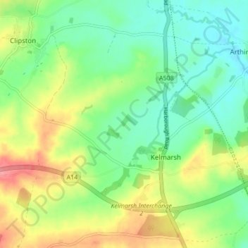
Name: Kelmarsh topographic map, elevation, terrain.
Location: Kelmarsh, West Northamptonshire, England, United Kingdom (52.39473 -0.95652 52.43395 -0.88817)
Average elevation: 453 ft
Minimum elevation: 348 ft
Maximum elevation: 623 ft
Other topographic maps
Click on a map to view its topography, its elevation and its terrain.
Lower Thorpe
United Kingdom > England > West Northamptonshire > Thorpe Mandeville
Average elevation: 505 ft
Upton Country Park
United Kingdom > England > West Northamptonshire > Harpole
Average elevation: 246 ft
Abington Park
United Kingdom > England > West Northamptonshire > Northampton
Average elevation: 279 ft
Ravensthorpe Reservoir
United Kingdom > England > West Northamptonshire > Coton
Average elevation: 430 ft
Courteenhall
United Kingdom > England > West Northamptonshire > Courteenhall
Average elevation: 351 ft