
Doba topographic map
Interactive map
Click on the map to display elevation.
About this map
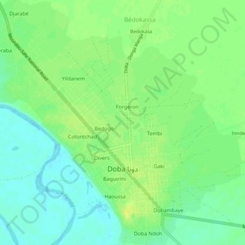
Name: Doba topographic map, elevation, terrain.
Location: Doba, Logone Oriental, Tchad (8.64602 16.82790 8.68873 16.87171)
Average elevation: 1,273 ft
Minimum elevation: 1,240 ft
Maximum elevation: 1,306 ft
Other topographic maps
Click on a map to view its topography, its elevation and its terrain.
Lybie
Tchad > Logone Oriental > Binguélé
Lybie, Binguélé, Logone Oriental, Tchad
Average elevation: 1,572 ft
Begada 1
Tchad > Logone Oriental > Begada 1
Begada 1, Logone Oriental, Tchad
Average elevation: 1,283 ft