Geolocate

Ngaram-Ngolé topographic map

Interactive map

Click on the map to display elevation.

About this map

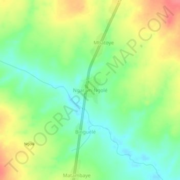
Name: Ngaram-Ngolé topographic map, elevation, terrain.

Location: Ngaram-Ngolé, Logone Oriental, Tchad (7.90861 15.64366 7.94861 15.68366)

Average elevation: 1,591 ft

Minimum elevation: 1,496 ft

Maximum elevation: 1,716 ft

Other topographic maps

Click on a map to view its topography, its elevation and its terrain.

Bebala

Tchad > Logone Oriental

Bebala, Logone Oriental, Tchad

Average elevation: 1,519 ft

Doba

Tchad > Logone Oriental

Doba, Logone Oriental, Tchad

Average elevation: 1,273 ft

Lybie

Tchad > Logone Oriental > Binguélé

Lybie, Binguélé, Logone Oriental, Tchad

Average elevation: 1,572 ft

Matiti

Tchad > Logone Oriental > Matiti

Matiti, Logone Oriental, Tchad

Average elevation: 1,385 ft

Begada 1

Tchad > Logone Oriental > Begada 1

Begada 1, Logone Oriental, Tchad

Average elevation: 1,283 ft

Nassian

Tchad > Logone Oriental

Nassian, Logone Oriental, Tchad

Average elevation: 1,253 ft

Logone لوقون

Tchad > Logone Oriental

Logone لوقون, Logone Oriental, Tchad

Average elevation: 1,306 ft

Logone

Tchad > Logone Oriental > Logone

Logone, Logone Oriental, Tchad

Average elevation: 1,516 ft

Mbéré امبيري

Tchad > Logone Oriental

Mbéré امبيري, Logone Oriental, Tchad

Average elevation: 1,742 ft