Geolocate

Sumner topographic map

Click on the map to display elevation.

About this map

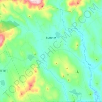
Name: Sumner topographic map, elevation, terrain.

Location: Sumner, Oxford County, Maine, 04292, United States (44.31665 -70.52517 44.43622 -70.35991)

Average elevation: 732 ft

Minimum elevation: 341 ft

Maximum elevation: 2,083 ft

Oxford County trails, hiking, mountain biking, running and outdoor activities

Other topographic maps

Click on a map to view its topography, its elevation and its terrain.

West Bethel

United States > Maine > Oxford County > Bethel

Average elevation: 827 ft

Record Hill

United States > Maine > Oxford County > Byron

Average elevation: 1,565 ft

Sunday River

United States > Maine > Oxford County > Bethel

Average elevation: 915 ft

Bryant Pond

United States > Maine > Oxford County > Woodstock

Average elevation: 886 ft

Grover Hill

United States > Maine > Oxford County

Average elevation: 817 ft

Old Speck Mountain

United States > Maine > Oxford County

Average elevation: 3,094 ft

Boston Hills

United States > Maine > Oxford County > Denmark

Average elevation: 446 ft

Sugarloaf

United States > Maine > Oxford County > Dixfield

Average elevation: 778 ft

Gear up for your next adventure:

☀️Outdoor Sunscreen - High protection sunscreen for outdoor activities
🔋Solar Power Banks - Keep your GPS and phone charged in remote wilderness areas
🎒Waterproof Dry Bags - Keep your electronics and maps dry inside your pack
🧤Tactile Hiking Gloves - Keep hands warm while operating GPS and smartphone screens
🚑Emergency Bivvies - Heat-reflective sleeping bags for survival situations

As an Amazon Associate, this site earns from qualifying purchases at no extra cost to you.