Geolocate

Mulvane topographic map

Click on the map to display elevation.

About this map

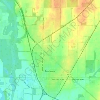
Name: Mulvane topographic map, elevation, terrain.

Location: Mulvane, Sedgwick County, Kansas, 67110, United States (37.46609 -97.26051 37.50890 -97.21957)

Average elevation: 1,266 ft

Minimum elevation: 1,207 ft

Maximum elevation: 1,332 ft

Sedgwick County trails, hiking, mountain biking, running and outdoor activities

Other topographic maps

Click on a map to view its topography, its elevation and its terrain.

Murray Gill

United States > Kansas > Sedgwick County

Average elevation: 1,296 ft

Sedgwick County Park

United States > Kansas > Sedgwick County

Average elevation: 1,332 ft

Furley

United States > Kansas > Sedgwick County

Average elevation: 1,398 ft

Sand Burr Hill

United States > Kansas > Sedgwick County > Wichita

Average elevation: 1,263 ft

Wichita

United States > Kansas > Sedgwick County > Wichita

Average elevation: 1,345 ft

Gear up for your next adventure:

🛌Ultralight Sleeping Bags - Compact down bags for cold nights in the wilderness
🎒Trail Energy Bars - High‑calorie bars for hiking energy
🪶Camping Sleeping Pad - Comfortable sleeping pad for backpacking
🧥Waterproof Jacket for Hiking - Breathable and rugged rain jacket for outdoor excursions
🪶Compact Camp Shovel - Folding shovel for campsite tasks

As an Amazon Associate, this site earns from qualifying purchases at no extra cost to you.