
Make a donation
Gear up for your next adventure:
As an Amazon Associate, this site earns from qualifying purchases at no extra cost to you.
Furley topographic map
Click on the map to display elevation.
Make a donation
Gear up for your next adventure:
As an Amazon Associate, this site earns from qualifying purchases at no extra cost to you.
About this map
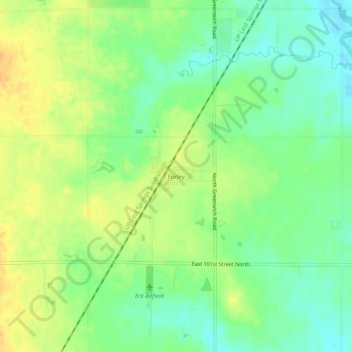
Name: Furley topographic map, elevation, terrain.
Location: Furley, Sedgwick County, Kansas, United States (37.85918 -97.23282 37.89918 -97.19282)
Average elevation: 1,398 ft
Minimum elevation: 1,345 ft
Maximum elevation: 1,453 ft
Sedgwick County trails, hiking, mountain biking, running and outdoor activities
Make a donation
Gear up for your next adventure:
As an Amazon Associate, this site earns from qualifying purchases at no extra cost to you.
Other topographic maps
Click on a map to view its topography, its elevation and its terrain.
Wichita
United States > Kansas > Sedgwick County
Wichita features a predominantly flat and gently rolling landscape characteristic of the Great Plains region. The city sits at an elevation of approximately 1,300 feet above sea level and is crisscrossed by several small rivers, including the Arkansas River, which flows through the city, providing a slight…
Average elevation: 1,339 ft
Make a donation
Gear up for your next adventure:
As an Amazon Associate, this site earns from qualifying purchases at no extra cost to you.
Goddard
United States > Kansas > Sedgwick County
Goddard is located at 37°39′35″N 97°34′27″W / 37.65972°N 97.57417°W / 37.65972; -97.57417 (37.659706, -97.574271) at an elevation of 1,463 feet (446 m). Goddard lies on U.S. Route 54 in south-central Kansas, immediately west of Wichita.
Average elevation: 1,453 ft
Wichita
United States > Kansas > Sedgwick County
The city lies on the Arkansas River near the western edge of the Flint Hills in the Wellington-McPherson Lowlands region of the Great Plains. The area's topography is characterized by the broad alluvial plain of the Arkansas River valley and the moderately rolling slopes that rise to the higher lands on either…
Average elevation: 1,339 ft
Make a donation
Gear up for your next adventure:
As an Amazon Associate, this site earns from qualifying purchases at no extra cost to you.
Wichita
United States > Kansas > Sedgwick County
The city lies on the Arkansas River near the western edge of the Flint Hills in the Wellington-McPherson Lowlands region of the Great Plains. The area's topography is characterized by the broad alluvial plain of the Arkansas River valley and the moderately rolling slopes that rise to the higher lands on either…
Average elevation: 1,339 ft
Make a donation
Gear up for your next adventure:
As an Amazon Associate, this site earns from qualifying purchases at no extra cost to you.
Wichita
United States > Kansas > Sedgwick County
The city lies on the Arkansas River near the western edge of the Flint Hills in the Wellington-McPherson Lowlands region of the Great Plains. The area's topography is characterized by the broad alluvial plain of the Arkansas River valley and the moderately rolling slopes that rise to the higher lands on either…
Average elevation: 1,339 ft
Wichita
United States > Kansas > Sedgwick County
The city lies on the Arkansas River near the western edge of the Flint Hills in the Wellington-McPherson Lowlands region of the Great Plains. The area's topography is characterized by the broad alluvial plain of the Arkansas River valley and the moderately rolling slopes that rise to the higher lands on either…
Average elevation: 1,339 ft
Make a donation
Gear up for your next adventure:
As an Amazon Associate, this site earns from qualifying purchases at no extra cost to you.
Make a donation
Gear up for your next adventure:
As an Amazon Associate, this site earns from qualifying purchases at no extra cost to you.