
Make a donation
Gear up for your next adventure:
As an Amazon Associate, this site earns from qualifying purchases at no extra cost to you.
Pak Mat Lebai Island topographic map
Click on the map to display elevation.
Make a donation
Gear up for your next adventure:
As an Amazon Associate, this site earns from qualifying purchases at no extra cost to you.
About this map
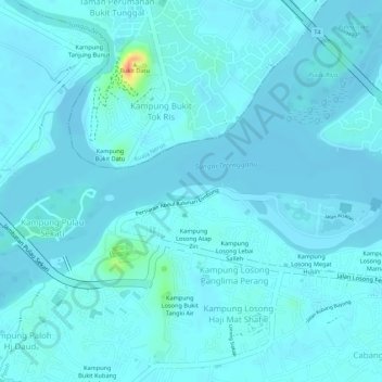
Name: Pak Mat Lebai Island topographic map, elevation, terrain.
Average elevation: 20 ft
Minimum elevation: -7 ft
Maximum elevation: 180 ft
Make a donation
Gear up for your next adventure:
As an Amazon Associate, this site earns from qualifying purchases at no extra cost to you.
Other topographic maps
Click on a map to view its topography, its elevation and its terrain.
Kampung Bukit Kecil
Malaysia > Terengganu > Kuala Terengganu > Kuala Terengganu
Average elevation: 30 ft
Kampung Gong Kapas
Malaysia > Terengganu > Kuala Terengganu > Kuala Terengganu
Average elevation: 30 ft
Make a donation
Gear up for your next adventure:
As an Amazon Associate, this site earns from qualifying purchases at no extra cost to you.