
Make a donation
Gear up for your next adventure:
As an Amazon Associate, this site earns from qualifying purchases at no extra cost to you.
Houthulst topographic map
Click on the map to display elevation.
Make a donation
Gear up for your next adventure:
As an Amazon Associate, this site earns from qualifying purchases at no extra cost to you.
Houthulst
Houthulst ligt in Zandlemig Vlaanderen, op een uitloper van de Midden-West-Vlaamse Heuvelrug op een hoogte van ongeveer 20 meter. Het hoogste punt is 30 meter, in het noordwesten van de kom. Bekend zijn de Zanddambeek en de Corverbeek.
Make a donation
Gear up for your next adventure:
As an Amazon Associate, this site earns from qualifying purchases at no extra cost to you.
About this map
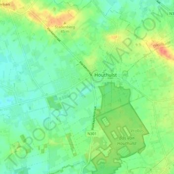
Name: Houthulst topographic map, elevation, terrain.
Location: Houthulst, Diksmuide, West-Vlaanderen, België (50.94853 2.92193 50.99925 2.97371)
Average elevation: 62 ft
Minimum elevation: 13 ft
Maximum elevation: 151 ft
Make a donation
Gear up for your next adventure:
As an Amazon Associate, this site earns from qualifying purchases at no extra cost to you.
Other topographic maps
Click on a map to view its topography, its elevation and its terrain.