
Make a donation
Gear up for your next adventure:
As an Amazon Associate, this site earns from qualifying purchases at no extra cost to you.
Jonkershove topographic map
Click on the map to display elevation.
Make a donation
Gear up for your next adventure:
As an Amazon Associate, this site earns from qualifying purchases at no extra cost to you.
About this map
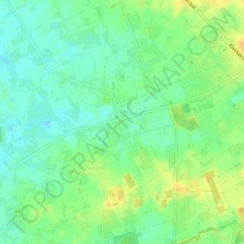
Name: Jonkershove topographic map, elevation, terrain.
Location: Jonkershove, Houthulst, Diksmuide, West-Vlaanderen, 8650, België (50.94848 2.89235 50.98848 2.93235)
Average elevation: 43 ft
Minimum elevation: 10 ft
Maximum elevation: 89 ft
Make a donation
Gear up for your next adventure:
As an Amazon Associate, this site earns from qualifying purchases at no extra cost to you.
Other topographic maps
Click on a map to view its topography, its elevation and its terrain.
Houthulst
België > West-Vlaanderen > Diksmuide > Houthulst
Houthulst ligt in Zandlemig Vlaanderen, op een uitloper van de Midden-West-Vlaamse Heuvelrug op een hoogte van ongeveer 20 meter. Het hoogste punt is 30 meter, in het noordwesten van de kom. Bekend zijn de Zanddambeek en de Corverbeek.
Average elevation: 62 ft
Merkem
België > West-Vlaanderen > Diksmuide > Houthulst
Merkem ligt op de westgrens van Zandlemig Vlaanderen, op een hoogte van 5 tot 10 meter. Ten westen daarvan bevindt zich de polderstreek, met de Sint-Jansbeek, de Ieperlee en de IJzer. In het noorden bevindt zich het broekgebied De Blankaart.
Average elevation: 16 ft
Klerken
België > West-Vlaanderen > Diksmuide > Houthulst
Klerken ligt op de zuidwestflank van de Midden-West-Vlaamse Heuvelrug. Het dorpscentrum van Klerken is daarom een stuk hoger gelegen dan de omliggende dorpen. De kerk ligt op ongeveer 37 meter hoogte. Het hoogste punt, nabij de Vredesmolen, ligt op 43 meter boven de zeespiegel. De kerk en het dorpscentrum zelf…
Average elevation: 43 ft
Make a donation
Gear up for your next adventure:
As an Amazon Associate, this site earns from qualifying purchases at no extra cost to you.