Geolocate

Trois-Rivières topographic map

Click on the map to display elevation.

About this map

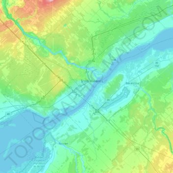
Name: Trois-Rivières topographic map, elevation, terrain.

Location: Trois-Rivières, Mauricie, Quebec, G9A 2H1, Canada (46.18323 -72.70285 46.50323 -72.38285)

Average elevation: 125 ft

Minimum elevation: 3 ft

Maximum elevation: 627 ft

Gear up for your next adventure:

🥄Camping Utensil Set - Lightweight utensils for outdoor meals
🥾Women's Hiking Boots - Top-rated trail boots with ankle support and superior grip
🎒Outdoor Daypacks - Lightweight backpacks designed for carrying maps and essential gear
🪶Camping Sleeping Pad - Comfortable sleeping pad for backpacking
👟Men's Trail Runners - Lightweight footwear for fast-paced exploration and light hiking

As an Amazon Associate, this site earns from qualifying purchases at no extra cost to you.