Geolocate

Stonefield topographic map

Click on the map to display elevation.

About this map

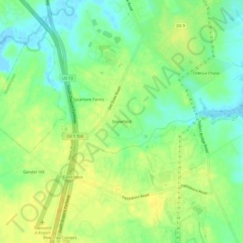
Name: Stonefield topographic map, elevation, terrain.

Location: Stonefield, New Castle County, Delaware, 19730, United States (39.40646 -75.66816 39.44646 -75.62816)

Average elevation: 43 ft

Minimum elevation: -7 ft

Maximum elevation: 79 ft

New Castle County trails, hiking, mountain biking, running and outdoor activities

Other topographic maps

Click on a map to view its topography, its elevation and its terrain.

Ardentown

United States > Delaware > New Castle County

Average elevation: 292 ft

Odessa

United States > Delaware > New Castle County

Average elevation: 33 ft

Arden

United States > Delaware > New Castle County

Average elevation: 259 ft

Newport

United States > Delaware > New Castle County

Average elevation: 43 ft

Elsmere

United States > Delaware > New Castle County

Average elevation: 98 ft

Townsend

United States > Delaware > New Castle County

Average elevation: 59 ft

Greenville

United States > Delaware > New Castle County

Average elevation: 276 ft

Claymont

United States > Delaware > New Castle County

Average elevation: 92 ft

Townsend

United States > Delaware > New Castle County

Average elevation: 59 ft

Gear up for your next adventure:

🗺️Topographic Maps - Detailed topo maps for hiking, exploring and outdoor navigation
🧭GPS Watch Accessories - Bands and chargers for GPS watches
🧦Hiking Socks - Comfortable socks to prevent blisters on long hikes
🥇GPS Hiking Watch - Multi‑sport GPS watch with navigation and trail tracking
🪶Camping Sleeping Pad - Comfortable sleeping pad for backpacking

As an Amazon Associate, this site earns from qualifying purchases at no extra cost to you.