
Make a donation
Gear up for your next adventure:
As an Amazon Associate, this site earns from qualifying purchases at no extra cost to you.
Volland topographic map
Click on the map to display elevation.
Make a donation
Gear up for your next adventure:
As an Amazon Associate, this site earns from qualifying purchases at no extra cost to you.
About this map
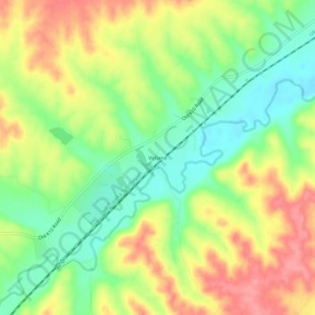
Name: Volland topographic map, elevation, terrain.
Location: Volland, Wabaunsee County, Kansas, United States (38.92445 -96.42444 38.96445 -96.38444)
Average elevation: 1,270 ft
Minimum elevation: 1,135 ft
Maximum elevation: 1,421 ft
Wabaunsee County trails, hiking, mountain biking, running and outdoor activities
Make a donation
Gear up for your next adventure:
As an Amazon Associate, this site earns from qualifying purchases at no extra cost to you.
Other topographic maps
Click on a map to view its topography, its elevation and its terrain.
Alta Vista
United States > Kansas > Wabaunsee County
Alta Vista was founded in 1887, and it was incorporated as a city in 1905. Alta Vista is derived from the Spanish word for "high view", and the city was so named from its lofty elevation.
Average elevation: 1,453 ft
Mount Mitchell Heritage Prairie Park
United States > Kansas > Wabaunsee County > Wamego
Average elevation: 1,066 ft
Make a donation
Gear up for your next adventure:
As an Amazon Associate, this site earns from qualifying purchases at no extra cost to you.
Maple Hill
United States > Kansas > Wabaunsee County
Maple Hill was founded about 1882. It was named from a grove of maple trees growing upon an elevation.
Average elevation: 978 ft