
McFarland topographic map
Interactive map
Click on the map to display elevation.
About this map
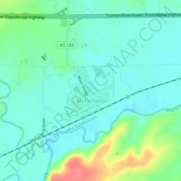
Name: McFarland topographic map, elevation, terrain.
Location: McFarland, Wabaunsee County, Kansas, 66501, United States (39.05056 -96.24229 39.05792 -96.23320)
Average elevation: 1,050 ft
Minimum elevation: 991 ft
Maximum elevation: 1,227 ft
Other topographic maps
Click on a map to view its topography, its elevation and its terrain.
Maple Hill
United States > Kansas > Wabaunsee County
Maple Hill, Wabaunsee County, Kansas, United States
Average elevation: 978 ft
Paxico
United States > Kansas > Wabaunsee County
Paxico, Wabaunsee County, Kansas, 66526, United States
Average elevation: 1,017 ft
Alta Vista
United States > Kansas > Wabaunsee County
Alta Vista, Wabaunsee County, Kansas, United States
Average elevation: 1,453 ft
Volland
United States > Kansas > Wabaunsee County
Volland, Wabaunsee County, Kansas, United States
Average elevation: 1,270 ft
Eskridge
United States > Kansas > Wabaunsee County
Eskridge, Wabaunsee County, Kansas, United States
Average elevation: 1,434 ft
Mount Mitchell Heritage Prairie Park
United States > Kansas > Wabaunsee County > Wamego
Mount Mitchell Heritage Prairie Park, 29377, Mitchell Prairie Lane, Wamego, Wabaunsee County, Kansas, 66547, United States
Average elevation: 1,066 ft
Harveyville
United States > Kansas > Wabaunsee County > Harveyville
Harveyville, Wabaunsee County, Kansas, United States
Average elevation: 1,152 ft
Alma
United States > Kansas > Wabaunsee County
Alma, Wabaunsee County, Kansas, United States
Average elevation: 1,096 ft