
Make a donation
Gear up for your next adventure:
As an Amazon Associate, this site earns from qualifying purchases at no extra cost to you.
Big Mink Lake topographic map
Click on the map to display elevation.
Make a donation
Gear up for your next adventure:
As an Amazon Associate, this site earns from qualifying purchases at no extra cost to you.
About this map
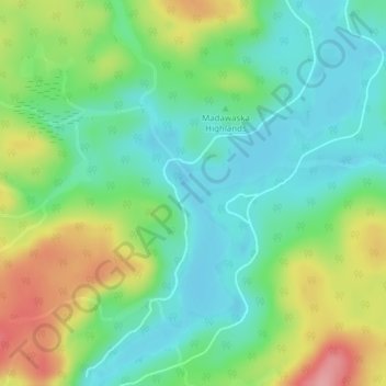
Name: Big Mink Lake topographic map, elevation, terrain.
Average elevation: 1,463 ft
Minimum elevation: 1,325 ft
Maximum elevation: 1,722 ft
Make a donation
Gear up for your next adventure:
As an Amazon Associate, this site earns from qualifying purchases at no extra cost to you.
Other topographic maps
Click on a map to view its topography, its elevation and its terrain.
Little Papineau Lake
Canada > Ontario > Hastings County > Hastings Highlands
Average elevation: 1,178 ft
Baptiste Lake
Canada > Ontario > Hastings County > Hastings Highlands > Baptiste Village
Average elevation: 1,322 ft
Make a donation
Gear up for your next adventure:
As an Amazon Associate, this site earns from qualifying purchases at no extra cost to you.