Geolocate

Princeton topographic map

Click on the map to display elevation.

About this map

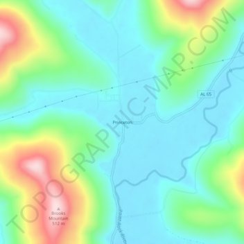
Name: Princeton topographic map, elevation, terrain.

Location: Princeton, Jackson County, Alabama, 35766, United States (34.82342 -86.26304 34.86342 -86.22304)

Average elevation: 896 ft

Minimum elevation: 614 ft

Maximum elevation: 1,644 ft

Jackson County trails, hiking, mountain biking, running and outdoor activities

Other topographic maps

Click on a map to view its topography, its elevation and its terrain.

Skyline

United States > Alabama > Jackson County

Average elevation: 1,276 ft

Langston

United States > Alabama > Jackson County

Average elevation: 797 ft

Paint Rock

United States > Alabama > Jackson County

Average elevation: 810 ft

Pleasant Groves

United States > Alabama > Jackson County

Average elevation: 1,086 ft

Hytop

United States > Alabama > Jackson County

Average elevation: 1,355 ft

Dutton

United States > Alabama > Jackson County

Average elevation: 1,345 ft

Scottsboro

United States > Alabama > Jackson County

Average elevation: 771 ft

Stevenson

United States > Alabama > Jackson County

Average elevation: 810 ft

Paint Rock

United States > Alabama > Jackson County

Average elevation: 817 ft

Pisgah

United States > Alabama > Jackson County > Pisgah

Average elevation: 1,375 ft

Gear up for your next adventure:

🎒Waterproof Dry Bags - Keep your electronics and maps dry inside your pack
🛰️Handheld GPS Units - Professional satellite navigators for precise backcountry mapping
🏔️Mountain Trail Maps - High‑detail maps for popular peaks
📶Vehicle Signal Boosters - Improve reception in rural areas while driving to trailheads
💧Water Filtration Bottles - Safely drink from streams and lakes while exploring

As an Amazon Associate, this site earns from qualifying purchases at no extra cost to you.