Geolocate

Great Skellig topographic map

Interactive map

Click on the map to display elevation.
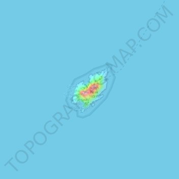
About this map

Name: Great Skellig topographic map, elevation, terrain.

Location: Great Skellig, Kenmare Municipal District, County Kerry, Munster, Ireland (51.76784 -10.54505 51.77471 -10.53603)

Average elevation: 3 ft

Minimum elevation: 0 ft

Maximum elevation: 528 ft

Skellig Michael consists of approximately 22 hectares (54 acres) of rock, with its highest point, known as the Spit, 218 m (714 ft) above sea level. The island is defined by its twin peaks and intervening valley (known as Christ's Saddle), which make its landscape steep and inhospitable. It is best known for its Gaelic monastery, founded between the 6th and 8th centuries, and its variety of inhabiting species, which include gannets, puffins, a colony of razorbills and a population of approximately fifty grey seals. The island is of special interest to archaeologists, as the monastic settlement is in unusually good condition. The rock contains the remains of a tower house, a megalithic stone row and a cross-inscribed slab known as the Wailing Woman. The monastery is situated at an elevation of 170 to 180 m (550 to 600 ft), Christ's Saddle at 129 m (422 ft), and the flagstaff area at 37 m (120 ft) above sea level.

Wikipedia (CC-BY-SA 3.0)

Other topographic maps

Click on a map to view its topography, its elevation and its terrain.

Killarney

Ireland > County Kerry

Killarney, Killarney Municipal District, County Kerry, Munster, Ireland

Average elevation: 187 ft

Brick

Ireland > County Kerry

Brick, Lixnaw ED, Listowel Municipal District, County Kerry, Munster, Ireland

Average elevation: 16 ft

Caher

Ireland > County Kerry

Caher, Kenmare Municipal District, County Kerry, Munster, V93 A8N1, Ireland

Average elevation: 2,024 ft

Kenmare Municipal District

Ireland > County Kerry

Kenmare Municipal District, County Kerry, Munster, Ireland

Average elevation: 322 ft

Tralee

Ireland > County Kerry > Tralee

Tralee, Tralee Municipal District, County Kerry, Munster, Ireland

Average elevation: 66 ft

Dingle

Ireland > County Kerry

Dingle, Kenmare Municipal District, County Kerry, Munster, Ireland

Average elevation: 397 ft

Brick

Ireland > County Kerry

Brick, Lixnaw ED, Listowel Municipal District, County Kerry, Munster, Ireland

Average elevation: 16 ft

Carrauntoohil

Ireland > County Kerry

Carrauntoohil, Kenmare Municipal District, County Kerry, Munster, V93 A8N1, Ireland

Average elevation: 2,113 ft