
Make a donation
Gear up for your next adventure:
As an Amazon Associate, this site earns from qualifying purchases at no extra cost to you.
Kenmare Municipal District topographic map
Click on the map to display elevation.
Make a donation
Gear up for your next adventure:
As an Amazon Associate, this site earns from qualifying purchases at no extra cost to you.
About this map
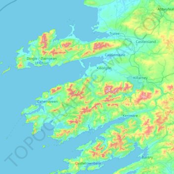
Name: Kenmare Municipal District topographic map, elevation, terrain.
Location: Kenmare Municipal District, County Kerry, Munster, Ireland (51.68820 -10.61844 52.33778 -9.27401)
Average elevation: 322 ft
Minimum elevation: -10 ft
Maximum elevation: 3,284 ft
Make a donation
Gear up for your next adventure:
As an Amazon Associate, this site earns from qualifying purchases at no extra cost to you.
Other topographic maps
Click on a map to view its topography, its elevation and its terrain.
Great Skellig
Skellig Michael consists of approximately 22 hectares (54 acres) of rock, with its highest point, known as the Spit, 218 m (714 ft) above sea level. The island is defined by its twin peaks and intervening valley (known as Christ's Saddle), which make its landscape steep and inhospitable. It is best known for…
Average elevation: 3 ft
Make a donation
Gear up for your next adventure:
As an Amazon Associate, this site earns from qualifying purchases at no extra cost to you.