
Make a donation
Gear up for your next adventure:
As an Amazon Associate, this site earns from qualifying purchases at no extra cost to you.
Shirleysburg topographic map
Click on the map to display elevation.
Make a donation
Gear up for your next adventure:
As an Amazon Associate, this site earns from qualifying purchases at no extra cost to you.
About this map
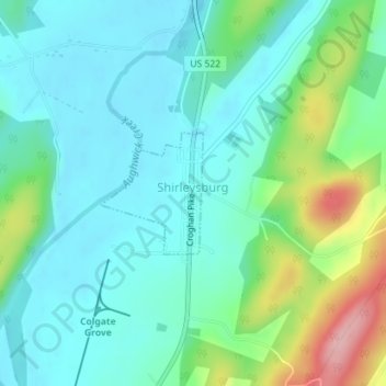
Name: Shirleysburg topographic map, elevation, terrain.
Location: Shirleysburg, Huntingdon County, Pennsylvania, United States (40.29314 -77.88267 40.30169 -77.87320)
Average elevation: 686 ft
Minimum elevation: 545 ft
Maximum elevation: 1,119 ft
Huntingdon County trails, hiking, mountain biking, running and outdoor activities
Make a donation
Gear up for your next adventure:
As an Amazon Associate, this site earns from qualifying purchases at no extra cost to you.
Other topographic maps
Click on a map to view its topography, its elevation and its terrain.
Warriors Mark
United States > Pennsylvania > Huntingdon County > Warriors Mark Township
Average elevation: 1,214 ft
Make a donation
Gear up for your next adventure:
As an Amazon Associate, this site earns from qualifying purchases at no extra cost to you.
Spruce Creek
United States > Pennsylvania > Huntingdon County > Spruce Creek Township
Average elevation: 1,079 ft
Saulsburg
United States > Pennsylvania > Huntingdon County > Barree Township
Average elevation: 994 ft
Robertsdale
United States > Pennsylvania > Huntingdon County > Wood Township
Average elevation: 1,939 ft
Puttstown
United States > Pennsylvania > Huntingdon County > Hopewell Township
Average elevation: 1,083 ft
Make a donation
Gear up for your next adventure:
As an Amazon Associate, this site earns from qualifying purchases at no extra cost to you.
Pennsylvania Furnace
United States > Pennsylvania > Huntingdon County > Franklin Township
Average elevation: 1,191 ft
Nossville
United States > Pennsylvania > Huntingdon County > Tell Township
Average elevation: 1,119 ft
Neelyton
United States > Pennsylvania > Huntingdon County > Dublin Township
Average elevation: 1,181 ft
McAlevys Fort
United States > Pennsylvania > Huntingdon County > Jackson Township
Average elevation: 869 ft
Make a donation
Gear up for your next adventure:
As an Amazon Associate, this site earns from qualifying purchases at no extra cost to you.
McConnellstown
United States > Pennsylvania > Huntingdon County > Walker Township
Average elevation: 843 ft
Make a donation
Gear up for your next adventure:
As an Amazon Associate, this site earns from qualifying purchases at no extra cost to you.
Blairs Mills
United States > Pennsylvania > Huntingdon County > Tell Township
Average elevation: 928 ft
Lake Jeanette
United States > Pennsylvania > Huntingdon County > Jackson Township
Average elevation: 879 ft
Entriken
United States > Pennsylvania > Huntingdon County > Lincoln Township
Average elevation: 1,063 ft
Water Street
United States > Pennsylvania > Huntingdon County > Morris Township
Average elevation: 1,047 ft
Make a donation
Gear up for your next adventure:
As an Amazon Associate, this site earns from qualifying purchases at no extra cost to you.