
Make a donation
Gear up for your next adventure:
As an Amazon Associate, this site earns from qualifying purchases at no extra cost to you.
Entriken topographic map
Click on the map to display elevation.
Make a donation
Gear up for your next adventure:
As an Amazon Associate, this site earns from qualifying purchases at no extra cost to you.
About this map
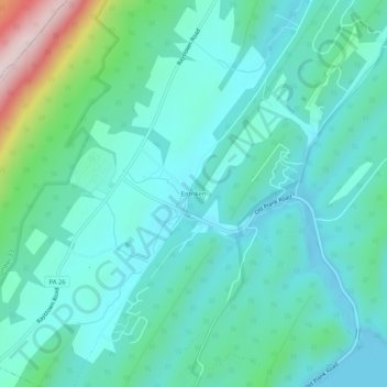
Name: Entriken topographic map, elevation, terrain.
Average elevation: 1,063 ft
Minimum elevation: 784 ft
Maximum elevation: 2,231 ft
Huntingdon County trails, hiking, mountain biking, running and outdoor activities
Make a donation
Gear up for your next adventure:
As an Amazon Associate, this site earns from qualifying purchases at no extra cost to you.
Other topographic maps
Click on a map to view its topography, its elevation and its terrain.
Raystown Lake
United States > Pennsylvania > Huntingdon County > Lincoln Township
The proposal for the new dam incorporated the ideas of bringing tourism into the area, promoting recreation, and flood control. The actual purpose stated, "The project will provide flood control, recreation, water quality and fish and wildlife enhancement" (U.S. Army Corps of Engineers, 1974). Although tourism…
Average elevation: 1,247 ft