Geolocate

River Nith topographic map

Click on the map to display elevation.

About this map

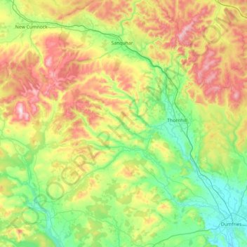
Name: River Nith topographic map, elevation, terrain.

Location: River Nith, Dumfries and Galloway, Scotland, United Kingdom (54.97786 -4.31062 55.40158 -3.56998)

Average elevation: 758 ft

Minimum elevation: 0 ft

Maximum elevation: 2,595 ft

Other topographic maps

Click on a map to view its topography, its elevation and its terrain.

Dob's Linn

United Kingdom > Scotland > Dumfries and Galloway

Average elevation: 1,532 ft

Loch Skeen

United Kingdom > Scotland > Dumfries and Galloway

Average elevation: 1,995 ft

Loch Enoch

United Kingdom > Scotland > Dumfries and Galloway

Average elevation: 1,696 ft

Rhinns of Kellsc

United Kingdom > Scotland > Dumfries and Galloway

'Rhinns' derives from the Old Irish rind, later Ulster Irish and Scottish Gaelic rinn, meaning 'promontory' or 'point'. 'Kells' is a parish in the historic county of Stewartry of Kirkcudbright to the southeast of the range near New Galloway. Its name possibly derives from the Old Irish cell, later Irish and…

Average elevation: 1,155 ft

Loch Dè

United Kingdom > Scotland > Dumfries and Galloway

Average elevation: 1,004 ft

Annan

United Kingdom > Scotland > Dumfries and Galloway

Average elevation: 82 ft

Moffat

United Kingdom > Scotland > Dumfries and Galloway

Average elevation: 738 ft

Burnhead

United Kingdom > Scotland > Dumfries and Galloway

Average elevation: 240 ft

Moniaive

United Kingdom > Scotland > Dumfries and Galloway

Average elevation: 587 ft

Gretna

United Kingdom > Scotland > Dumfries and Galloway

Average elevation: 62 ft

Caldons

United Kingdom > Scotland > Dumfries and Galloway

Average elevation: 682 ft

Eskdalemuir

United Kingdom > Scotland > Dumfries and Galloway

In spite of it being located inland, the dull and wet nature of the climate due to the elevation leads to chilly summers that are colder than more northerly locations such as Glasgow and Edinburgh. The inland nature of the climate is more manifest during winter months with frosts being common, and the average…

Average elevation: 807 ft

Wanlockhead

United Kingdom > Scotland > Dumfries and Galloway

Average elevation: 1,539 ft

Langholm

United Kingdom > Scotland > Dumfries and Galloway

Average elevation: 607 ft

Ley Hill

United Kingdom > Scotland > Dumfries and Galloway

Average elevation: 702 ft

Ae

United Kingdom > Scotland > Dumfries and Galloway

Average elevation: 640 ft

Tynron

United Kingdom > Scotland > Dumfries and Galloway > Tynron

Average elevation: 636 ft

Gelston

United Kingdom > Scotland > Dumfries and Galloway > Gelston

Average elevation: 295 ft

Boreland

United Kingdom > Scotland > Dumfries and Galloway

Average elevation: 636 ft

Borgue

United Kingdom > Scotland > Dumfries and Galloway

Average elevation: 164 ft

Beattock

United Kingdom > Scotland > Dumfries and Galloway

Average elevation: 472 ft

Penpont

United Kingdom > Scotland > Dumfries and Galloway

Average elevation: 322 ft

Fingland

United Kingdom > Scotland > Dumfries and Galloway

Average elevation: 676 ft

Drummore

United Kingdom > Scotland > Dumfries and Galloway

Average elevation: 118 ft

Twynholm

United Kingdom > Scotland > Dumfries and Galloway

Average elevation: 236 ft

Kirkcolm

United Kingdom > Scotland > Dumfries and Galloway

Average elevation: 102 ft

Monreith

United Kingdom > Scotland > Dumfries and Galloway

Average elevation: 108 ft

Arkleton

United Kingdom > Scotland > Dumfries and Galloway

Average elevation: 774 ft

Saddle Yoke

United Kingdom > Scotland > Dumfries and Galloway

Average elevation: 1,467 ft

Courance

United Kingdom > Scotland > Dumfries and Galloway

Average elevation: 371 ft

Whithorn

United Kingdom > Scotland > Dumfries and Galloway

Average elevation: 184 ft

Corsock

United Kingdom > Scotland > Dumfries and Galloway

Average elevation: 512 ft

Bran Rig

United Kingdom > Scotland > Dumfries and Galloway

Average elevation: 643 ft

Milton

United Kingdom > Scotland > Dumfries and Galloway

Average elevation: 404 ft

Colt Hill

United Kingdom > Scotland > Dumfries and Galloway

Average elevation: 1,542 ft

Evertown

United Kingdom > Scotland > Dumfries and Galloway

Average elevation: 289 ft

Mennock

United Kingdom > Scotland > Dumfries and Galloway

Average elevation: 633 ft

Creetown

United Kingdom > Scotland > Dumfries and Galloway

Average elevation: 203 ft

Glenluce

United Kingdom > Scotland > Dumfries and Galloway

Average elevation: 154 ft

Gear up for your next adventure:

🛏️Cold Weather Sleeping Bag - Warm sleeping bag for cold conditions
🌧️Backpack Rain Cover - Keep gear dry in wet weather
🎒Hydration Pack - Hands‑free water reservoir for long hikes
🪶Wildlife Field Guides - Learn animal tracking and species ID
🥾Hiking Shoes - Durable and comfortable shoes for trail hiking

As an Amazon Associate, this site earns from qualifying purchases at no extra cost to you.