
Make a donation
Gear up for your next adventure:
As an Amazon Associate, this site earns from qualifying purchases at no extra cost to you.
Carr topographic map
Click on the map to display elevation.
Make a donation
Gear up for your next adventure:
As an Amazon Associate, this site earns from qualifying purchases at no extra cost to you.
About this map
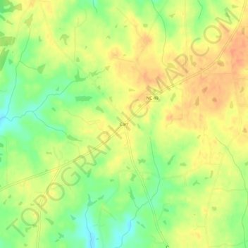
Name: Carr topographic map, elevation, terrain.
Location: Carr, Orange County, North Carolina, United States (36.19153 -79.24002 36.23153 -79.20002)
Average elevation: 702 ft
Minimum elevation: 623 ft
Maximum elevation: 755 ft
Make a donation
Gear up for your next adventure:
As an Amazon Associate, this site earns from qualifying purchases at no extra cost to you.
Other topographic maps
Click on a map to view its topography, its elevation and its terrain.
Make a donation
Gear up for your next adventure:
As an Amazon Associate, this site earns from qualifying purchases at no extra cost to you.
Eno River State Park
United States > North Carolina > Orange County > Hillsborough
The Cox Mountain Trail is marked by blue blazes. The 3.75-mile (6.04 km) trail passes a picnic area and crosses the suspension foot bridge. The trail goes up 270 feet (82 m) in elevation and at one point follows Hillsborough Coach Road. When getting closer to Cox Mountain, the trail can get fairly steep. The…
Average elevation: 545 ft
Historic Occoneechee Speedway
United States > North Carolina > Orange County > Hillsborough
Average elevation: 574 ft
Make a donation
Gear up for your next adventure:
As an Amazon Associate, this site earns from qualifying purchases at no extra cost to you.
Mason Farm Biological Reserve
United States > North Carolina > Orange County > Chapel Hill
Average elevation: 285 ft
Make a donation
Gear up for your next adventure:
As an Amazon Associate, this site earns from qualifying purchases at no extra cost to you.