Geolocate

Perm topographic map

Click on the map to display elevation.

About this map

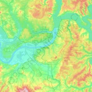
Name: Perm topographic map, elevation, terrain.

Location: Perm, Perm District, Perm Krai, Volga Federal District, Russia (57.86767 55.79892 58.17715 56.65664)

Average elevation: 502 ft

Minimum elevation: 276 ft

Maximum elevation: 1,145 ft

Gear up for your next adventure:

❄️Traction Cleats - Prevent slips on icy trails during winter hikes
🔪Outdoor Multitools - Essential survival tools for gear repair and field use
🕶️GPS Smartphone Mount - Secure mount for phone navigation
🔦Compact Flashlight - Reliable flashlight for emergencies
🌲Outdoor Survival Books - Best books on survival skills

As an Amazon Associate, this site earns from qualifying purchases at no extra cost to you.