Geolocate

Marshall topographic map

Click on the map to display elevation.

About this map

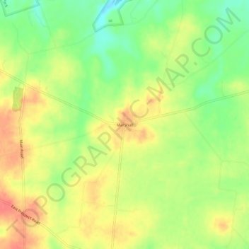
Name: Marshall topographic map, elevation, terrain.

Location: Marshall, Highland County, Ohio, United States (39.13201 -83.50492 39.17201 -83.46492)

Average elevation: 981 ft

Minimum elevation: 873 ft

Maximum elevation: 1,079 ft

Highland County trails, hiking, mountain biking, running and outdoor activities

Other topographic maps

Click on a map to view its topography, its elevation and its terrain.

Rocky Fork Lake

United States > Ohio > Highland County

Average elevation: 955 ft

Mowrystown

United States > Ohio > Highland County

Average elevation: 981 ft

Lynchburg

United States > Ohio > Highland County

Average elevation: 1,017 ft

Hillsboro

United States > Ohio > Highland County

Average elevation: 1,027 ft

Highland

United States > Ohio > Highland County

Average elevation: 1,070 ft

Paint Creek Lake

United States > Ohio > Highland County

Average elevation: 909 ft

Gear up for your next adventure:

Camping Coffee Makers - Enjoy premium coffee at the summit or campsite
🔦LED Headlamp - Bright and durable LED headlamp for night navigation
📦Gear Storage Bags - Organize and protect outdoor equipment
Backpacking Tent - Lightweight and durable tent for multi‑day hikes
🦟Ultrasonic Repellers - Create a bug-free zone at your camp or rest stop

As an Amazon Associate, this site earns from qualifying purchases at no extra cost to you.