Geolocate

Westmont topographic map

Click on the map to display elevation.

About this map

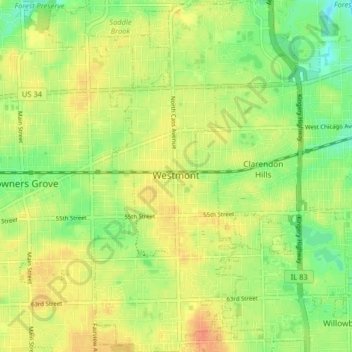
Name: Westmont topographic map, elevation, terrain.

Location: Westmont, DuPage County, Illinois, 60559, United States (41.76483 -87.99423 41.82505 -87.94695)

Average elevation: 745 ft

Minimum elevation: 676 ft

Maximum elevation: 801 ft

DuPage County trails, hiking, mountain biking, running and outdoor activities

Other topographic maps

Click on a map to view its topography, its elevation and its terrain.

Elmhurst

United States > Illinois > DuPage County

Due to local topography, the town has had a tendency to flood in the past after large rainfalls; the city is currently undertaking a large effort to mitigate future flooding.

Average elevation: 679 ft

Morton Arboretum

United States > Illinois > DuPage County > Lisle

Average elevation: 722 ft

Elmhurst

United States > Illinois > DuPage County

Due to local topography, the town has had a tendency to flood in the past after large rainfalls; the city is currently undertaking a large effort to mitigate future flooding.

Average elevation: 679 ft

Wheaton

United States > Illinois > DuPage County

Average elevation: 761 ft

Elmhurst

United States > Illinois > DuPage County

Due to local topography, the town has had a tendency to flood in the past after large rainfalls; the city is currently undertaking a large effort to mitigate future flooding.

Average elevation: 679 ft

Medinah

United States > Illinois > DuPage County

Average elevation: 738 ft

Gear up for your next adventure:

🗺️Topographic Maps - Detailed topo maps for hiking, exploring and outdoor navigation
🎁Geography Themed Gifts - Unique gift ideas for map lovers and geography enthusiasts
🧼Biodegradable Camping Soap - Eco‑friendly soap for outdoor hygiene
📱Heavy-Duty Phone Cases - Drop-proof and waterproof protection for outdoor navigation
🕶️GPS Smartphone Mount - Secure mount for phone navigation

As an Amazon Associate, this site earns from qualifying purchases at no extra cost to you.