
Thank you for supporting this site ❤️
Make a donation
Make a donation
Gear up for your next adventure:
As an Amazon Associate, this site earns from qualifying purchases at no extra cost to you.
Altötting topographic map
Click on the map to display elevation.
Thank you for supporting this site ❤️
Make a donation
Make a donation
Gear up for your next adventure:
As an Amazon Associate, this site earns from qualifying purchases at no extra cost to you.
About this map
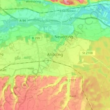
Name: Altötting topographic map, elevation, terrain.
Location: Altötting, Landkreis Altötting, Bavaria, 84503, Germany (48.19974 12.60763 48.25306 12.73285)
Average elevation: 1,332 ft
Minimum elevation: 1,161 ft
Maximum elevation: 1,565 ft
Thank you for supporting this site ❤️
Make a donation
Make a donation
Gear up for your next adventure:
As an Amazon Associate, this site earns from qualifying purchases at no extra cost to you.