Geolocate

O'Fallon topographic map

Click on the map to display elevation.

About this map

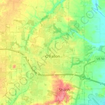
Name: O'Fallon topographic map, elevation, terrain.

Location: O'Fallon, Saint Clair County, Illinois, 62269, United States (38.54740 -89.96664 38.64393 -89.85814)

Average elevation: 538 ft

Minimum elevation: 436 ft

Maximum elevation: 673 ft

Saint Clair County trails, hiking, mountain biking, running and outdoor activities

Other topographic maps

Click on a map to view its topography, its elevation and its terrain.

Bohleysville

United States > Illinois > Saint Clair County

Average elevation: 610 ft

Shiloh

United States > Illinois > Saint Clair County > Shiloh > Shiloh

Average elevation: 518 ft

Gear up for your next adventure:

🔭Compact Binoculars - HD vision for scouting terrain and identifying distant landmarks
🔪Outdoor Multitools - Essential survival tools for gear repair and field use
🗃️Trail First Aid Kit - Essential kit for outdoor injuries and emergencies
📷Action Camera - Capture your outdoor adventures in HD
🎒Trekking Poles - Sturdy poles for balance and stability on rough terrain

As an Amazon Associate, this site earns from qualifying purchases at no extra cost to you.