Geolocate

Fairfield topographic map

Click on the map to display elevation.

About this map

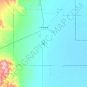
Name: Fairfield topographic map, elevation, terrain.

Location: Fairfield, Utah County, Utah, United States (40.20307 -112.13954 40.28365 -112.00571)

Average elevation: 5,013 ft

Minimum elevation: 4,829 ft

Maximum elevation: 6,181 ft

Utah County trails, hiking, mountain biking, running and outdoor activities

Other topographic maps

Click on a map to view its topography, its elevation and its terrain.

Townsend

United States > Utah > Utah County > Genola

Average elevation: 4,718 ft

Aspen Grove

United States > Utah > Utah County

Average elevation: 7,736 ft

Olmsted

United States > Utah > Utah County > Orem

Average elevation: 5,230 ft

Bicentennial Park

United States > Utah > Utah County > Provo

Average elevation: 4,810 ft

Edgemont

United States > Utah > Utah County > Provo

Average elevation: 5,046 ft

Lehi

United States > Utah > Utah County > Lehi

Average elevation: 5,518 ft

Birdseye

United States > Utah > Utah County

Average elevation: 5,840 ft

Geneva

United States > Utah > Utah County > Orem > Geneva

Average elevation: 4,564 ft

Deer Creek

United States > Utah > Utah County

Average elevation: 6,991 ft

Gear up for your next adventure:

🪶Fire Starter Kit - Reliable fire starter for survival and camping
🔦LED Headlamp - Bright and durable LED headlamp for night navigation
GPS Sports Watch - GPS watch for running, hiking and training
🥾Hiking Shoes - Durable and comfortable shoes for trail hiking
🔥Plasma Lighters - Windproof lighters that work in any weather condition

As an Amazon Associate, this site earns from qualifying purchases at no extra cost to you.