Geolocate

Ronceverte topographic map

Click on the map to display elevation.

About this map

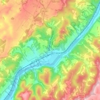
Name: Ronceverte topographic map, elevation, terrain.

Location: Ronceverte, Greenbrier County, West Virginia, 24970, United States (37.73675 -80.50367 37.76503 -80.44736)

Average elevation: 1,988 ft

Minimum elevation: 1,624 ft

Maximum elevation: 2,356 ft

Greenbrier County trails, hiking, mountain biking, running and outdoor activities

Other topographic maps

Click on a map to view its topography, its elevation and its terrain.

Frankford

United States > West Virginia > Greenbrier County

Average elevation: 2,231 ft

Anjean

United States > West Virginia > Greenbrier County

Average elevation: 3,186 ft

Dawson

United States > West Virginia > Greenbrier County

Average elevation: 2,493 ft

Clearco

United States > West Virginia > Greenbrier County

Average elevation: 3,704 ft

Modoc

United States > West Virginia > Greenbrier County

Average elevation: 2,300 ft

Duo

United States > West Virginia > Greenbrier County

Average elevation: 3,478 ft

Alvon

United States > West Virginia > Greenbrier County > Alvon

Average elevation: 2,231 ft

Gear up for your next adventure:

🧯Portable Fire Pit - Compact fire pit for camping spots
📦Dry Bags Set - Waterproof storage for electronics and clothes
🛰️Satellite Messengers - Emergency SOS and two-way messaging for off-grid adventures
🧣Merino Neck Gaiters - Multi-functional headwear for wind and sun protection
🥩Freeze-Dried Meals - Nutritious and lightweight food for remote expeditions

As an Amazon Associate, this site earns from qualifying purchases at no extra cost to you.