
Make a donation
Gear up for your next adventure:
As an Amazon Associate, this site earns from qualifying purchases at no extra cost to you.
Alfred topographic map
Click on the map to display elevation.
Make a donation
Gear up for your next adventure:
As an Amazon Associate, this site earns from qualifying purchases at no extra cost to you.
Alfred
According to the United States Census Bureau, the town has a total area of 27.92 square miles (72.31 km2), of which 27.25 square miles (70.58 km2) is land and 0.67 square miles (1.74 km2) is water. Alfred is drained by the Middle Branch of the Mousam River, Littlefield River, Hay Brook and Trafton Brook. Yeaton Hill has an elevation of 602 feet (183 m), and Brackett Hill an elevation of 480 feet (150 m). The highest point in town is on Fort Ridge, at an elevation of 1,020 feet (310 m), at the Shapleigh line.
Make a donation
Gear up for your next adventure:
As an Amazon Associate, this site earns from qualifying purchases at no extra cost to you.
About this map
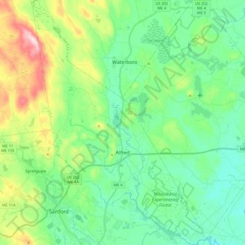
Name: Alfred topographic map, elevation, terrain.
Location: Alfred, York County, Maine, 04002, United States (43.41703 -70.79837 43.57548 -70.64232)
Average elevation: 364 ft
Minimum elevation: 92 ft
Maximum elevation: 1,102 ft
York County trails, hiking, mountain biking, running and outdoor activities
Make a donation
Gear up for your next adventure:
As an Amazon Associate, this site earns from qualifying purchases at no extra cost to you.
Other topographic maps
Click on a map to view its topography, its elevation and its terrain.
Make a donation
Gear up for your next adventure:
As an Amazon Associate, this site earns from qualifying purchases at no extra cost to you.
Make a donation
Gear up for your next adventure:
As an Amazon Associate, this site earns from qualifying purchases at no extra cost to you.