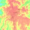
Summerdale topographic map
Click on the map to display elevation.
Summerdale
The Navy Outlying Landing Field (NOLF) Summerdale airport is on the east side of Summerdale (at latitude, longitude: 30.507695, –87.645541). The Airport Code is NFD, in region: ASO - Southern, with boundary ARTCC: ZJX - Jacksonville, and Tie-in FSS: ANB - Anniston. The airport runway length/width is 2850 x 150 ft (868.7 x 45.7 m), with runway elevation: 149 feet (45 m). The airport is owned/operated by the US Navy, through Commanding Officer, Operations Department, 7077 USS Lexington Court, Milton, FL 32570-6016.
About this map
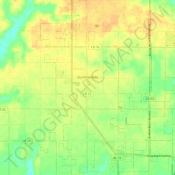
Name: Summerdale topographic map, elevation, terrain.
Location: Summerdale, Baldwin County, Alabama, United States (30.44195 -87.72695 30.52367 -87.63225)
Average elevation: 105 ft
Minimum elevation: 49 ft
Maximum elevation: 144 ft
Baldwin County trails, hiking, mountain biking, running and outdoor activities
Other topographic maps
Click on a map to view its topography, its elevation and its terrain.
Ono Island
United States > Alabama > Baldwin County
Ono Island was along the boundary of the treaties between France and Spain. In 1813, after protests and attempts at rebellion, President James Monroe seized Spanish lands west of the Perdido River and declared them a part of the Louisiana Purchase of 1803. This set the east end of the Island, Perdido Key, at…
Average elevation: 3 ft




Ono Island
United States > Alabama > Baldwin County
Ono Island was along the boundary of the treaties between France and Spain. In 1813, after protests and attempts at rebellion, President James Monroe seized Spanish lands west of the Perdido River and declared them a part of the Louisiana Purchase of 1803. This set the east end of the Island, Perdido Key, at…
Average elevation: 30 ft