
Make a donation
Gear up for your next adventure:
As an Amazon Associate, this site earns from qualifying purchases at no extra cost to you.
Ono Island topographic map
Click on the map to display elevation.
Make a donation
Gear up for your next adventure:
As an Amazon Associate, this site earns from qualifying purchases at no extra cost to you.
Ono Island
Ono Island was along the boundary of the treaties between France and Spain. In 1813, after protests and attempts at rebellion, President James Monroe seized Spanish lands west of the Perdido River and declared them a part of the Louisiana Purchase of 1803. This set the east end of the Island, Perdido Key, at the mouth of the Perdido River, as the boundary between the United States and Spain. That same boundary would later mark the boundary between Alabama and Florida. Ono Island has previously been known as "Goat Island" or "George Kee's Island". George Kee, a caretaker for land belonging to Fred Scott. Scott was an early developer in the Perdido Key area and acquired Ono Island (alongside Innerarity point and other land) via Spanish land grants in the 1820s. Scott brought in goats and allowed them to roam free until there were an estimated 2,000 goats on the island, plus the wild hogs that Kee allowed anyone to shoot for food. At that time, the island was uninhabited except a small house Kee occupied that he built himself. A hurricane in 1916 changed the topography of the island by closing the Key and creating a new opening on the western end of the island. When Florida attempted to claim the land between the old pass and the new, Alabama legislators replied "Oh no you don't." That gave rise to the name, Ono Island.
Make a donation
Gear up for your next adventure:
As an Amazon Associate, this site earns from qualifying purchases at no extra cost to you.
About this map
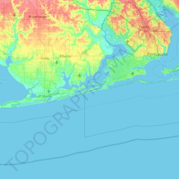
Name: Ono Island topographic map, elevation, terrain.
Location: Ono Island, Baldwin County, Alabama, United States (29.97353 -87.81748 30.61353 -87.17748)
Average elevation: 30 ft
Minimum elevation: -13 ft
Maximum elevation: 180 ft
Baldwin County trails, hiking, mountain biking, running and outdoor activities
Make a donation
Gear up for your next adventure:
As an Amazon Associate, this site earns from qualifying purchases at no extra cost to you.
Other topographic maps
Click on a map to view its topography, its elevation and its terrain.
Fairhope
United States > Alabama > Baldwin County > Fairhope
According to the U.S. Census Bureau, the city has a total area of 12.0 square miles (31.1 km2), of which 0.019 square mile (0.05 km2), or 0.16%, is water. Its elevation ranges from sea level at the bay to 122 feet (37 m) in the city center.
Average elevation: 115 ft
Make a donation
Gear up for your next adventure:
As an Amazon Associate, this site earns from qualifying purchases at no extra cost to you.
Fairhope
United States > Alabama > Baldwin County > Fairhope
According to the U.S. Census Bureau, the city has a total area of 12.0 square miles (31.1 km2), of which 0.019 square mile (0.05 km2), or 0.16%, is water. Its elevation ranges from sea level at the bay to 122 feet (37 m) in the city center.
Average elevation: 115 ft