
Make a donation
Gear up for your next adventure:
As an Amazon Associate, this site earns from qualifying purchases at no extra cost to you.
Rheurdt topographic map
Click on the map to display elevation.
Make a donation
Gear up for your next adventure:
As an Amazon Associate, this site earns from qualifying purchases at no extra cost to you.
Rheurdt
Rheurdt liegt linksrheinisch im niederrheinischen Tiefland auf einer Höhe von 30 bis 80 m ü. NN. Durch das Gemeindegebiet fließen die Nenneper Fleuth, der Littardsche Kendel und der Landwehrbach. In Nord-Süd-Richtung verlaufen die Rheurdter und Schaephuysener Höhen, eine Endmoräne aus der Saaleeiszeit.
Make a donation
Gear up for your next adventure:
As an Amazon Associate, this site earns from qualifying purchases at no extra cost to you.
About this map
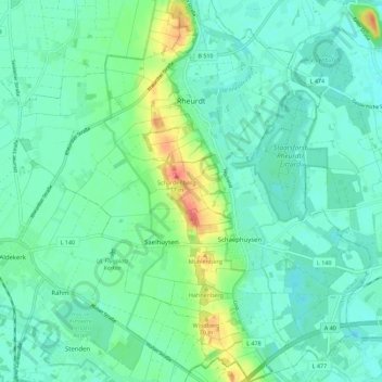
Name: Rheurdt topographic map, elevation, terrain.
Location: Rheurdt, Kreis Kleve, Nordrhein-Westfalen, 47509, Deutschland (51.41628 6.41809 51.48616 6.52186)
Average elevation: 118 ft
Minimum elevation: 72 ft
Maximum elevation: 259 ft
Make a donation
Gear up for your next adventure:
As an Amazon Associate, this site earns from qualifying purchases at no extra cost to you.
Other topographic maps
Click on a map to view its topography, its elevation and its terrain.
Make a donation
Gear up for your next adventure:
As an Amazon Associate, this site earns from qualifying purchases at no extra cost to you.
Make a donation
Gear up for your next adventure:
As an Amazon Associate, this site earns from qualifying purchases at no extra cost to you.
Pfalzdorf
Deutschland > Nordrhein-Westfalen > Kreis Kleve > Goch
Pfalzdorf liegt links des Rheins im niederrheinischen Tiefland zwischen Goch, Kalkar und Kleve auf den Pfalzdorfer Höhen, einem Teil des Niederrheinischen Höhenzugs. Benachbarte Orte sind Bedburg-Hau im Norden, Louisendorf im Nordosten, Keppeln im Osten, Goch im Süden, Asperden im Südwesten und Nierswalde…
Average elevation: 82 ft
Make a donation
Gear up for your next adventure:
As an Amazon Associate, this site earns from qualifying purchases at no extra cost to you.
Make a donation
Gear up for your next adventure:
As an Amazon Associate, this site earns from qualifying purchases at no extra cost to you.
Make a donation
Gear up for your next adventure:
As an Amazon Associate, this site earns from qualifying purchases at no extra cost to you.
Ferienpark Kevelaer
Deutschland > Nordrhein-Westfalen > Kreis Kleve > Kevelaer > Schravelnsche Heide
Average elevation: 69 ft
Make a donation
Gear up for your next adventure:
As an Amazon Associate, this site earns from qualifying purchases at no extra cost to you.
Make a donation
Gear up for your next adventure:
As an Amazon Associate, this site earns from qualifying purchases at no extra cost to you.
Make a donation
Gear up for your next adventure:
As an Amazon Associate, this site earns from qualifying purchases at no extra cost to you.
Make a donation
Gear up for your next adventure:
As an Amazon Associate, this site earns from qualifying purchases at no extra cost to you.
Gieselberg
Deutschland > Nordrhein-Westfalen > Kreis Kleve > Straelen > Auwel > Bormig
Average elevation: 115 ft
Make a donation
Gear up for your next adventure:
As an Amazon Associate, this site earns from qualifying purchases at no extra cost to you.
Pfalzdorf
Deutschland > Nordrhein-Westfalen > Kreis Kleve > Goch
Pfalzdorf liegt links des Rheins im niederrheinischen Tiefland zwischen Goch, Kalkar und Kleve auf den Pfalzdorfer Höhen, einem Teil des Niederrheinischen Höhenzugs. Benachbarte Orte sind Bedburg-Hau im Norden, Louisendorf im Nordosten, Keppeln im Osten, Goch im Süden, Asperden im Südwesten und Nierswalde…
Average elevation: 82 ft
Make a donation
Gear up for your next adventure:
As an Amazon Associate, this site earns from qualifying purchases at no extra cost to you.