Geolocate

Parol topographic map

Click on the map to display elevation.

About this map

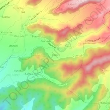
Name: Parol topographic map, elevation, terrain.

Location: Parol, Dharamshala, Kangra, Himachal Pradesh, 176209, India (32.12914 76.31199 32.16914 76.35199)

Average elevation: 2,976 ft

Minimum elevation: 2,484 ft

Maximum elevation: 3,471 ft

Other topographic maps

Click on a map to view its topography, its elevation and its terrain.

Kareri

India > Himachal Pradesh > Dharamshala

Average elevation: 6,066 ft

Balh

India > Himachal Pradesh > Dharamshala > Dharamshala

Average elevation: 6,253 ft

Gear up for your next adventure:

🚑Emergency Bivvies - Heat-reflective sleeping bags for survival situations
🔦LED Headlamp - Bright and durable LED headlamp for night navigation
🔭Stargazing Telescopes - Perfect for camping in low-light pollution areas shown on maps
🗺️NatGeo Topo Maps - High-quality waterproof printed topographic maps of US Parks
📷Action Cameras - Rugged cameras to document your journeys across rugged terrain

As an Amazon Associate, this site earns from qualifying purchases at no extra cost to you.