Geolocate

Balh topographic map

Click on the map to display elevation.

About this map

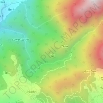
Name: Balh topographic map, elevation, terrain.

Location: Balh, Dharamshala, Kangra, Himachal Pradesh, 176200, India (32.25827 76.31118 32.26196 76.31825)

Average elevation: 6,253 ft

Minimum elevation: 4,544 ft

Maximum elevation: 8,510 ft

Other topographic maps

Click on a map to view its topography, its elevation and its terrain.

Darnu

India > Himachal Pradesh > Dharamshala > Dharamshala

Average elevation: 4,616 ft

Narghota

India > Himachal Pradesh > Dharamshala > Dharamshala

Average elevation: 3,635 ft

Kembli

India > Himachal Pradesh > Dharamshala > Dharamshala

Average elevation: 6,932 ft

Sukar

India > Himachal Pradesh > Dharamshala > Dharamshala

Average elevation: 3,911 ft

Narghota

India > Himachal Pradesh > Dharamshala > Dharamshala

Average elevation: 3,635 ft

Barnet

India > Himachal Pradesh > Dharamshala > Dharamshala

Average elevation: 4,678 ft

Gear up for your next adventure:

🧯Emergency Survival Kit - All‑in‑one survival essentials for the backcountry
🪶Paracord Bracelet - Survival bracelet with built‑in tools
💧Water Filtration Bottles - Safely drink from streams and lakes while exploring
📌Outdoor GPS Map App - Apps and devices for digital topographic navigation
🌎3D Topographic Globes - Raised relief globes for a tactile understanding of geography

As an Amazon Associate, this site earns from qualifying purchases at no extra cost to you.