Geolocate

Trefriw topographic map

Click on the map to display elevation.

About this map

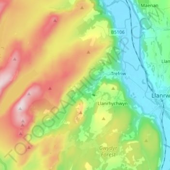
Name: Trefriw topographic map, elevation, terrain.

Location: Trefriw, Conwy, Wales, United Kingdom (53.10716 -3.91907 53.18426 -3.79282)

Average elevation: 856 ft

Minimum elevation: 7 ft

Maximum elevation: 2,185 ft

Other topographic maps

Click on a map to view its topography, its elevation and its terrain.

Llandudno Junction

United Kingdom > Wales > Conwy

Average elevation: 197 ft

Llanrhychwyn

United Kingdom > Wales > Conwy

Average elevation: 604 ft

Abergele

United Kingdom > Wales > Conwy

Average elevation: 184 ft

Llysfaen

United Kingdom > Wales > Conwy

Average elevation: 249 ft

Gear up for your next adventure:

🛠️Backpacking Tool Kit - Essential toolkit for outdoor repairs
🧭Pro Hiking Compasses - High-accuracy liquid-filled compasses for topographic orientation
🏫Relief Map Kits - Hands-on tools for teaching landforms and elevation
🔪Outdoor Multitools - Essential survival tools for gear repair and field use
📶Vehicle Signal Boosters - Improve reception in rural areas while driving to trailheads

As an Amazon Associate, this site earns from qualifying purchases at no extra cost to you.