Geolocate

Llysfaen topographic map

Click on the map to display elevation.

About this map

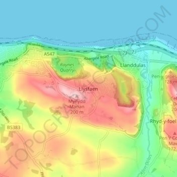
Name: Llysfaen topographic map, elevation, terrain.

Location: Llysfaen, Conwy, Wales, LL29 8ST, United Kingdom (53.26271 -3.67983 53.30271 -3.63983)

Average elevation: 249 ft

Minimum elevation: 0 ft

Maximum elevation: 669 ft

Other topographic maps

Click on a map to view its topography, its elevation and its terrain.

Trefriw

United Kingdom > Wales > Conwy

Average elevation: 856 ft

Gear up for your next adventure:

🎁Geography Themed Gifts - Unique gift ideas for map lovers and geography enthusiasts
❄️Traction Cleats - Prevent slips on icy trails during winter hikes
📻Weather Alert Radios - Stay informed of storm risks while off-the-grid
🌧️Backpack Rain Cover - Keep gear dry in wet weather
🥇GPS Hiking Watch - Multi‑sport GPS watch with navigation and trail tracking

As an Amazon Associate, this site earns from qualifying purchases at no extra cost to you.