Geolocate

Truro topographic map

Click on the map to display elevation.

About this map

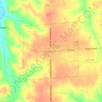
Name: Truro topographic map, elevation, terrain.

Location: Truro, Madison County, Iowa, United States (41.20211 -93.85639 41.21750 -93.83705)

Average elevation: 1,056 ft

Minimum elevation: 935 ft

Maximum elevation: 1,122 ft

Madison County trails, hiking, mountain biking, running and outdoor activities

Other topographic maps

Click on a map to view its topography, its elevation and its terrain.

Patterson

United States > Iowa > Madison County > Patterson > Patterson

Average elevation: 945 ft

Gear up for your next adventure:

🧥Waterproof Jacket for Hiking - Breathable and rugged rain jacket for outdoor excursions
🥘Titanium Cookware - Durable, featherlight pots and pans for backpacking
🧷Carabiner Set - Durable clips for gear attachment
🌡️Handheld Weather Meters - Measure wind, temp, and pressure for safe mountain travel
📱Heavy-Duty Phone Cases - Drop-proof and waterproof protection for outdoor navigation

As an Amazon Associate, this site earns from qualifying purchases at no extra cost to you.