
Colne topographic map
Click on the map to display elevation.
Colne
Pendle Leisure Trust runs the Pendle Leisure Centre next to the railway station. The facility has two swimming pools, a fitness centre and gymnasium, sauna and sports hall. In summer 2013, the outdoor all-weather pitch was replaced by Urban Altitude. This outdoor aerial assault course is the first of its kind to be built in the UK in an urban location. It includes high and low rope courses, up to 42 ft off the ground, a 60m Zip-Wire, Leap of Faith, Power Fan Free-fall, Jacobs Ladder and Climbing Wall.
About this map
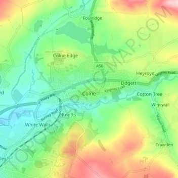
Name: Colne topographic map, elevation, terrain.
Location: Colne, Borough of Pendle, Lancashire, England, United Kingdom (53.84131 -2.20491 53.87446 -2.12707)
Average elevation: 646 ft
Minimum elevation: 400 ft
Maximum elevation: 1,076 ft
Other topographic maps
Click on a map to view its topography, its elevation and its terrain.
Colne Water
United Kingdom > England > Lancashire > Borough of Pendle > Laneshaw Bridge
Average elevation: 663 ft
Lad Law (Boulsworth Hill)
United Kingdom > England > Lancashire > Borough of Pendle
Average elevation: 1,342 ft