
Barley topographic map
Click on the map to display elevation.
About this map
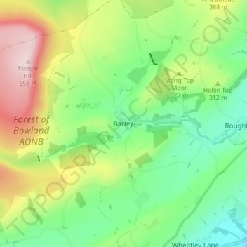
Name: Barley topographic map, elevation, terrain.
Average elevation: 961 ft
Minimum elevation: 446 ft
Maximum elevation: 1,827 ft
Other topographic maps
Click on a map to view its topography, its elevation and its terrain.
Colne Water
United Kingdom > England > Lancashire > Borough of Pendle > Laneshaw Bridge
Average elevation: 663 ft
Colne
United Kingdom > England > Lancashire > Borough of Pendle
Pendle Leisure Trust runs the Pendle Leisure Centre next to the railway station. The facility has two swimming pools, a fitness centre and gymnasium, sauna and sports hall. In summer 2013, the outdoor all-weather pitch was replaced by Urban Altitude. This outdoor aerial assault course is the first of its kind…
Average elevation: 646 ft
Laneshaw Bridge
United Kingdom > England > Lancashire > Borough of Pendle > Laneshaw Bridge
Average elevation: 883 ft
Barrowford
United Kingdom > England > Lancashire > Borough of Pendle > Barrowford
Average elevation: 528 ft
Barnoldswick
United Kingdom > England > Lancashire > Borough of Pendle > Salterforth
Average elevation: 574 ft
Colne
United Kingdom > England > Lancashire > Borough of Pendle
Pendle Leisure Trust runs the Pendle Leisure Centre next to the railway station. The facility has two swimming pools, a fitness centre and gymnasium, sauna and sports hall. In summer 2013, the outdoor all-weather pitch was replaced by Urban Altitude. This outdoor aerial assault course is the first of its kind…
Average elevation: 646 ft
Barnoldswick
United Kingdom > England > Lancashire > Borough of Pendle > Salterforth
Average elevation: 574 ft