
Curry topographic map
Click on the map to display elevation.
About this map
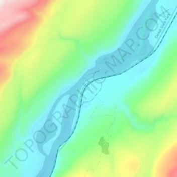
Name: Curry topographic map, elevation, terrain.
Location: Curry, Matanuska-Susitna Borough, Alaska, United States (62.59472 -150.03194 62.63472 -149.99194)
Average elevation: 1,079 ft
Minimum elevation: 492 ft
Maximum elevation: 2,585 ft
Matanuska-Susitna Borough trails, hiking, mountain biking, running and outdoor activities
Other topographic maps
Click on a map to view its topography, its elevation and its terrain.
Skwentna
United States > Alaska > Matanuska-Susitna Borough
Hayes River is a weather station near Skwentna to the northeast, at an elevation of 1,000 feet (300 m). Hayes River also has a subarctic climate (Köppen Dfc) but has a lower seasonal temperature variation and receives substantially more snow.
Average elevation: 666 ft
Denali State Park
United States > Alaska > Matanuska-Susitna Borough
Denali State Park is in sight of Denali, the highest mountain peak in North America, with a summit elevation of 20,310 feet above sea level. Denali rises 18,000 feet from base to peak, making it the largest mountain situated entirely above sea level. To the east, the state park borders the Susitna River, which…
Average elevation: 2,303 ft
Trapper Creek
United States > Alaska > Matanuska-Susitna Borough
Trapper Creek is a community located in Matanuska-Susitna Borough at latitude 62.317 and longitude -150.231, with an elevation of 351 ft (107 m). It is at mile 114.5 on the Parks Highway, just south of Denali State Park. Trapper Creek is found at the intersection of Petersville Road and is spread out along the…
Average elevation: 771 ft