
Fairmount topographic map
Click on the map to display elevation.
About this map
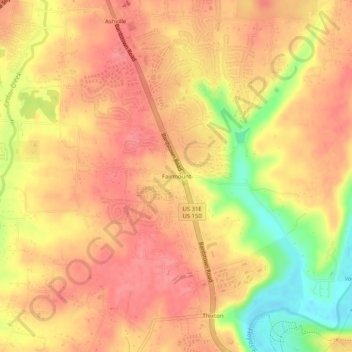
Name: Fairmount topographic map, elevation, terrain.
Average elevation: 650 ft
Minimum elevation: 472 ft
Maximum elevation: 728 ft
Jefferson County trails, hiking, mountain biking, running and outdoor activities
Other topographic maps
Click on a map to view its topography, its elevation and its terrain.
Iroquois Park
United States > Kentucky > Jefferson County > Louisville > Parkwood
Average elevation: 548 ft
E.P. "Tom" Sawyer State Park
United States > Kentucky > Jefferson County > Louisville > Lakeland
Average elevation: 686 ft
E.P. "Tom" Sawyer State Park
United States > Kentucky > Jefferson County > Louisville > Lakeland
Average elevation: 686 ft